Recent advances in systems integration enable precise interpretation of all electromagnetic, gravity and radiometric data gathered from Airbourne surveys and otherwise. That capability of integration is patented and uniquely able to evidence the precise extent and volume of water, hydrocarbon and mineral deposits many kilometers below the surface. This is a revelation of wealth that can be part of building the infrastructure of a nation for generations to come. The potential is so vast that the opportunity is best suited to become part of the Blockchain which is accessible to investors the world over. This is Exploration Exchange.

With this capability to locate and evaluate resources, XX is launching the X Coin as a proprietary platform token. Tokens can be held until the value of the recovery is known and reflected in the price and then the tokens may be sold back to GCC or exchanged into tokens of another resource platform or a different technology project on the GCC platform. Tokens are not redeemable for FIAT currency nor are they refundable during the developing value of the resource. Tokens are only issued after the structure of a probable resource has been identified. GCC XX is the world’s first resources backed token exchange.

The X Foundation funds projects all over the world in areas where GCC is undertaking mining and exploration activities. The X Foundation is part of GCC’s Gift Again Program where funds are invested and managed to provide long lasting sustainable funding for the Social, and Environmental projects that the Foundation is supporting. If you have a project project that needs to be funded please get in touch, especially if its any of the following areas:

  1. Environmental preservation
  2. Pollution and Waste Reduction
  3. Children’s Education
  4. Essential Infrustracture
  5. Water Resources

By downloading the GCC Wallet app on iPhone or iPad, you can top up your GBP, Euro or USD wallet account or transfer Bitcoin to the Bitcoin Wallet by going to the GCC Wallet website.


From there, you can then select the tokens you want to buy by simply clicking on the invest button. The wallet is provided by Baanx Group Ltd and tokens can be found at www.gcctokens.com.

DISRUPTIVE TECHNOLOGIES

SATELLITE MAPPING (SM)

GCC has created relationships that give access to proprietary technologies that identify subsurface materials many kilometres below the surface of the Earth or subsurface of the ocean. These technologies are sometimes in the public domain but all are either protected by patents or held secret until that patent is considered to be secure. The technologies exist to accurately define the presence and characteristics of water, oil and gas deposits and the
identity of specific mineralizations. The technologies can amplify subterranean signals that allow determination of the locality and an indication of the volume of underground resources. The importance to host nations and to the welfare of their future generations of peoples can hardly be exaggerated.

These technologies are revolutionary and subject to extreme protection as intellectual proprietary property because they can detect and evaluate everything that lies under the surface of every country worldwide.

Following up on the location and possible identity of a resource, an aerial survey gathers data that can be transformed into precise 3D images. These identify the structures and subsurface formations that hold the resources and they can be interrogated to measure exact volumes to the point of discrimination between all types of mineralisation. The data interrogation can reveal the characteristics and therefore the value of resources many kilometres down under the surface of the Earth. An aerial survey will cover each AOI with electromagnetic, gravitational and radiometric data-gathering technologies. The survey can be by land, marine or airborne and after that data gathering, recent IP protected advances in systems integration allow the most precise interpretation of the data into 3D images. These 3D models can be joined together. Magnification enables exactitude in the process of that evaluation of wealth and there is suddenly an ability to determine the preferred method of recovery. This may be used as a guide as to how best to recover the values, in what oder of importance and how long it will take.

Assessment of value under JORC normally requires drilling but technologies move on and new science is leading the way to an ability to assess the value of the recoverable material sufficiently accurately so as to attract institutional funding for that recovery. GCC intends to make the introductions that will fund the recovery cost so that resources hidden can become part of a monetisation process for poorer nations. Once the value of a resource is known, licenses can be issued to multinationals with fair agreements as to the allocation of new wealth.

AERIAL SURVEY & DATA INTERPRETATION

THE PRECISION OF SUB-SURFACE IMAGING

TI LLC

Aerial Surveying


Many technologies can see what lies beneath the ground in a small subsurface survey but the more advanced survey algorithms have moved on to overcome the confusion in complex mixtures and overlaps of signals emitted by all different materials. They are able to integrate and present the precise nature of the materials together with their extent and value.


With the various technologies available today, GCC has the means to provide the resource owners with information on the estimated value of the existing mineral resources before any permissions of governmental licenses are issued.

TECHNOIMAGING - PROPRIETARY TECHNOLOGY

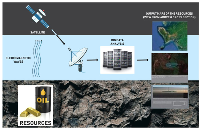
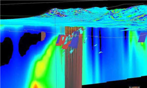
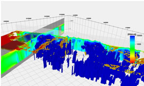
The TechnoImaging intellectual property and patent portfolio covers proprietary, transformational geological and geo-physical exploration techniques and 3D geo-positioning of strata, rock formations and every kind of resource and deposit using multi-physics data interrogation. These abilities come from exceptional technologies and algorithms developed by the undisputed scientific leaders in the field of geophysics based at the University of Utah in Salt Lake City and they are patent protected to prevent illegal competition.


The details of the assembly of these wide-reaching protections are referenced in over 800 published papers in the leading scientific journals. They cover integrating and jointly inverting all data to make the potential wealth of a nation transparent. This can lead to the unchallenged recovery of resources at minimum cost.


TI LLC is the only survey and data interpretation company to have such a patent stable. TI LLC contracts directly with Heads of State, Presidents, Governments and the offices of Prime Ministers on an exclusive nationwide survey basis and therefore, because of the patent protection of the intellectual property covering all areas of data discrimination, the relevant territorial authorities will protect the role of TI LLC against competitors in each client nation.


This protection is seen as a key to attracting funding. TI LLC operates lawfully under its own patents and there can be no challenge to its mapping activity. Moreover, the classification and evaluation of resources in the ground is protected in any presentation to funding bodies for a recovery program.

The host nations are in the first instance mindful to show that any application for funding or confirmation of an application for verification under JORC or the like will be recognised as a legitimate evaluation for institutional funding within the IMF, the World Bank and other global monetisation opportunities.


Importantly, the work ethic allows those poorer territories to evaluate their own wealth prior to the issuance of cheap licenses for a blind immediate and irrational rush to cash. The precision in survey can also provide protection from inevitable environmental damage.

On the left is an example of the super-magnification of a rock section for the identification of mineralization. This analysis was used in a pilot study in Saudi Arabia and identified unknown gold deposits in a remote area in the desert similar to the epithermal, low-sulfidation, polymetallic-type gold deposits in the mine at Mahd Ad Dahab (‘Cradle of Gold’) a gold mining area of the Hejazi region of the Arabian Peninsula which has been operating for circa 3,000 years.

GOVERNMENT INVOLVEMENT

GCC aims to create a path to wealth for territorial governments by alerting them to the existence of precious resources under their land and territorial waters.


GCC will appraise them of recovery values. This signals protection from unauthorised wildcatting, environmental abuse and pollution.


If Governments know in advance what value to lend to any area of interest (“AOI”) in their subsurface, nations and multinationals will work together to recover resources with a fair allocation of the potential profit.


GCC is working internationally to develop disruptive technologies in various fields of endeavour and to train local workforces in the associated areas of building infrastructure. The overall objective is to harness the wealth and strength of a nation through commercial innovation and the teaching of skills that will attract funding and the rollout of product and services.

THE GCC ADVANTAGE

GCC can use an aerial survey  to identify the location of an unknown source of water, hydrocarbon or mineral deposit without a need to find the deposit in the first place. This is dramatically cost effective. Instead of an indefinite interpretation of geophysical maps, proprietary algorithms are used to create computer models to expose even the rock formations that gave rise to the observed data. This is a new capability to understand the subsurface geology that hosts the various target resources and the analysis is sufficiently accurate as a pathway to develop projects.


After that initial resource identification by satellite and a follow up survey, an exact 3D model is created to render the Earth’s subsurface strata in a transparent format uncovering all its geological secrets several kilometres deep – a transparent underground world with clarity, scale, and unparallel accuracy.

OUR VALUES

To place emphasis on clients’ best interests with mutually attractive goals embracing a professional and ethical approach to moving forward. This is a business where great wealth lies undiscovered in areas of the world where the local communities experience exploitation and great hardship

We value our investors as part of a foundation in partnership

We pride ourselves in knowing that our diverse and experi- enced team is dedicated to delivering client service

To use best endeavours to strive in a program to generate wealth from extraordinary ideas that will involve entire populations in the universal objective of creating a better life

THE FUTURE

GCC has launched its Cryptocurrency/Blockchain platform with its own Digital Wallet www.GccWallet.UK. This wallet is positioned to tokenise technology projects in up to 50 international companies. The spread facilitates investors acquiring and storing GCC Tokens through an APP that is a simple download through the APP STORE and PLAY STORE.


GCC is providing investors with an end to end platform that is destined to become the world’s leading Regulated Asset Backed Resource Platform -www.eXploration.eXchange.


X Coin is the cryptocurrency access to a variety of project tokens.


Nuno Barroso

Exploration Exchange

Managing Director

Chris George

Exploration Exchange

Advisor – Mapping

Maggie Webber

Exploration Exchange

Advisor – Blockchain

Rasmus Andersen

Exploration Exchange

Advisor – Capital Management

Matthew Jones

Exploration Exchange

Advisor – Operations

Barnaby Andersun

Exploration Exchange

Advisor – Blockchain

Miguel Fernandes

Exploration Exchange

Chief – Technology Officer

Rob Cecil

Exploration Exchange

Advisor – Marketing